BCC Swamp, Drone Flight

I’ve been watching the weather for weeks and there just hasn’t been a good day for flying.  It seems that it is either raining/snowing or the wind is just to much for flying safely.  This morning there was finally a break, so I started sending emails at about 7am to see if I could get everything arranged for a 9:30am flight.  I got permission from BCC Security, and from the Pittsfield Airport.

The only challenge is that it was pointed out by one of BCC’s Environmental Science professors that there is a great deal of bird activity in that area as of now.  Keeping that in mind, I began to hunt around for someone who could act as a visual observer for this flight.  Nathan in the library was able to, so he was my VO keeping an eye out for birds, airplanes (which we did see one get close as we are within 5 miles of Pittsfield airport) and any other wildlife or hazards.  Nathan did a good job and we didn’t have any issues, or any near issues even.  The only wildlife we saw kept pretty far away, except for some smaller birds that became interested as we started to land.  Check out the full video below.

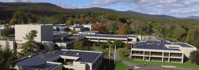
After we accomplished our mission goals, to get some video as an initial “survey” of the swamp area, Nathan got the chance to have a test flight to get an idea of how the sticks work.  He did great and his video is below!

I’m looking forward to the next flight, but the way the weather looks who knows when that might be!

Flight Over Frozen Cheshire Lake, With Insurance!

The weather for drone flying has been pretty crumby lately, although yesterday there was finally an opportunity.  While it was a little windy, sustained winds about 7mph and gusts at 400 feet of up to 25mph, I believed that the little Mavic Mini could handle it.  So around 11:30am on a sunny Sunday I headed down to the causeway at Cheshire Lake which is a super short distance from my home.

There were a number of people ice fishing, some folks feeding the geese, and a quite a few individuals simply enjoying the nice sunny weather, I think it got up to almost 50 degrees yesterday afternoon!  I also used this opportunity to test out the process for pay-by-the-hour insurance for my flight.  I did some research on the different apps and companies and decided to try SkyWatch.  I went with SkyWatch for a few reasons, first the app looked well put together, second it supported logging in with my Google account which I like because I hate filling out redundant forms and this simplified the process. The final reason I chose SkyWatch is because it was recommended by another drone pilot who’s opinion I hold in high regard.

The flight itself was a success!  The Mavic Mini performed great in the wind as I had thought it would.  I did get a high wind warning several times inside the DJI app and I didn’t fly much higher than 250 feet just to be safe and stay away from the worst of the gusts.  As always, I notice things in the video that I would improve if I had it to do again, and I’m sure I will be flying at this spot in the future so there will be a chance.

SkyWatch Policy

SkyWatch Policy Document

I was pretty happy with the insurance process from SkyWatch as well. Not only was it quite affordable at only $10 for an hour of coverage with up to $1 million in liability coverage, but the process was super simple.  I was even able to draw a box in the area where I planned to fly to make sure the quote was as accurate and affordable as it could be.  The whole process of buying insurance took maybe 5 minutes tops including the time to download the app.  Since there was a parking lot nearby, and some gusty wind, and with it being my first time flying at the lake, I wanted to have the extra piece of mind.  In the future when I have risky flights or fly in a location off BCC campus where insurance is required/necessary, I will definitely be using SkyWatch again.

The only thing I’m not sure about is the policy seemed to cover everything but my drone itself and I couldn’t seem to find options in the app to turn that on, if possible.  There were subscription plans that the app offered and perhaps you need to signup for a tier for that to be available. Always more to research, one of the things I enjoy about technology!

Physics of Drone Flight – Now With Maths!

This past Fall semester I gave a 60 minute Forum presentation for STEM on drones, the different types of drones, and the physics of drone flight.  Over the weekend a WIRED article from a few months back popped up on my news feed with some actual physics, as in with math, that students can perform on a drone!

To summarize the experiment, either myself in advance or students in the classroom would take a slow motion video of the drone accelerating forward. Then, using an open source software tool called Tracker, analyze the video to capture the angle of movement and take actual measurements for the acceleration of the drone.  There’s some compensation that needs to be done based on the frame rate of the camera, however one just need to keep this in mind. Once you know the acceleration, and then measure the mass of the drone, you can use F=MA calculate the force of the drone’s movement.   (It’s a little more complicated than this, I’m breaking it down to it’s simplest elements to explain easily.)

This could be a fun experiment for physics students to perform here at BCC or anywhere really.  The article is pretty in depth, and it shows how students can use Tracker to make a parabola and includes all of the equations needed.

This could be a fun subset of a drone presentation for STEM Starter Academy or perhaps just something to build into my next forum presentation.  I’m always on the lookout for ways to make my presentations more educational or ways to bring experiments with technology into the classroom.