Posted at 3:50 pm
Summary and Analysis:
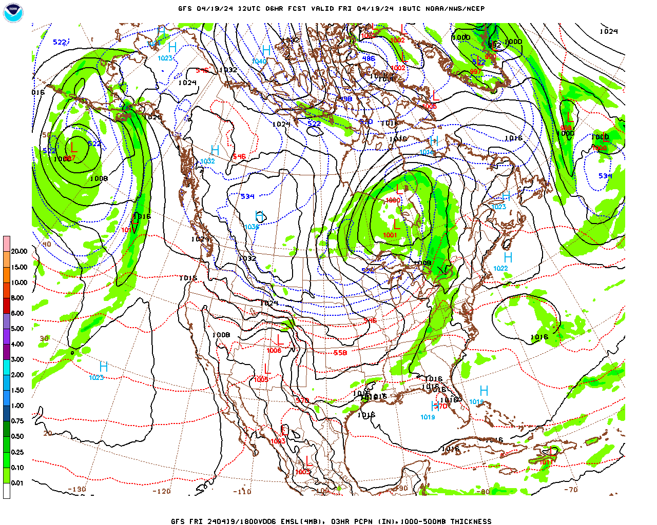
A complex, but relatively weak area of surface low pressure is moving through the Northeast this afternoon and evening, with one low centered over western PA and a second off the NJ coast. A broad and dominant trough in the jet stream wave pattern is centered over western Canada and the northern Great Plains, with the eastern edge of this trough located over the western Great Lakes. As the trough moved south from Canada the past few days, a concurrent ridge in the upper-level wave pattern developed over the Eastern US, with mild air surging northward into eastern portions of the Midwest and the East Coast with temperatures now above freezing in most of the Midwest, the entire Great Lakes, and virtually all of the East Coast except for northern Maine and the highest elevations of the elevated terrain. As a result, virtually all of the precipitation associated with this broad area of surface low pressure is falling in the form of rain. As of 3 pm, all reporting stations in Berkshire County are above freezing, except for Savoy, where the temperature is 32 ºF. Therefore, any threat for frozen precipitation for Berkshire County for the next 24 hours should be limited to the highest elevations of North County, where there could still be some freezing rain.
Steady rain will continue across the county through the evening, although rain should lighten up for a few hours during the late evening, ending by the early morning hours, around 2 am or so. As the low pressure system moves into eastern Canada and intensifies, the counter-clockwise circulation around the low will have a number of impacts for us. First of all, the eastern edge of the previously described upper-level trough will surge eastward and the cold front (polar front) associated with it will move across the county tomorrow. As a result, temperatures will start out fairly mild, but begin to drop during the afternoon, and particularly tomorrow (Wednesday) night. In addition, the pressure gradient will increase as the low deepens, so it will become quite breezy with wind chills dropping into the single digits by Thursday morning. Also, moisture circulating around the low, being lifted by the advancing cold front and our elevated terrain will result in scattered snow showers, and even a few squalls, Wednesday afternoon and evening. There will be some lake-effect snow but with winds more out of the west-southwest any snow showers should be limited to southern VT on Thursday.
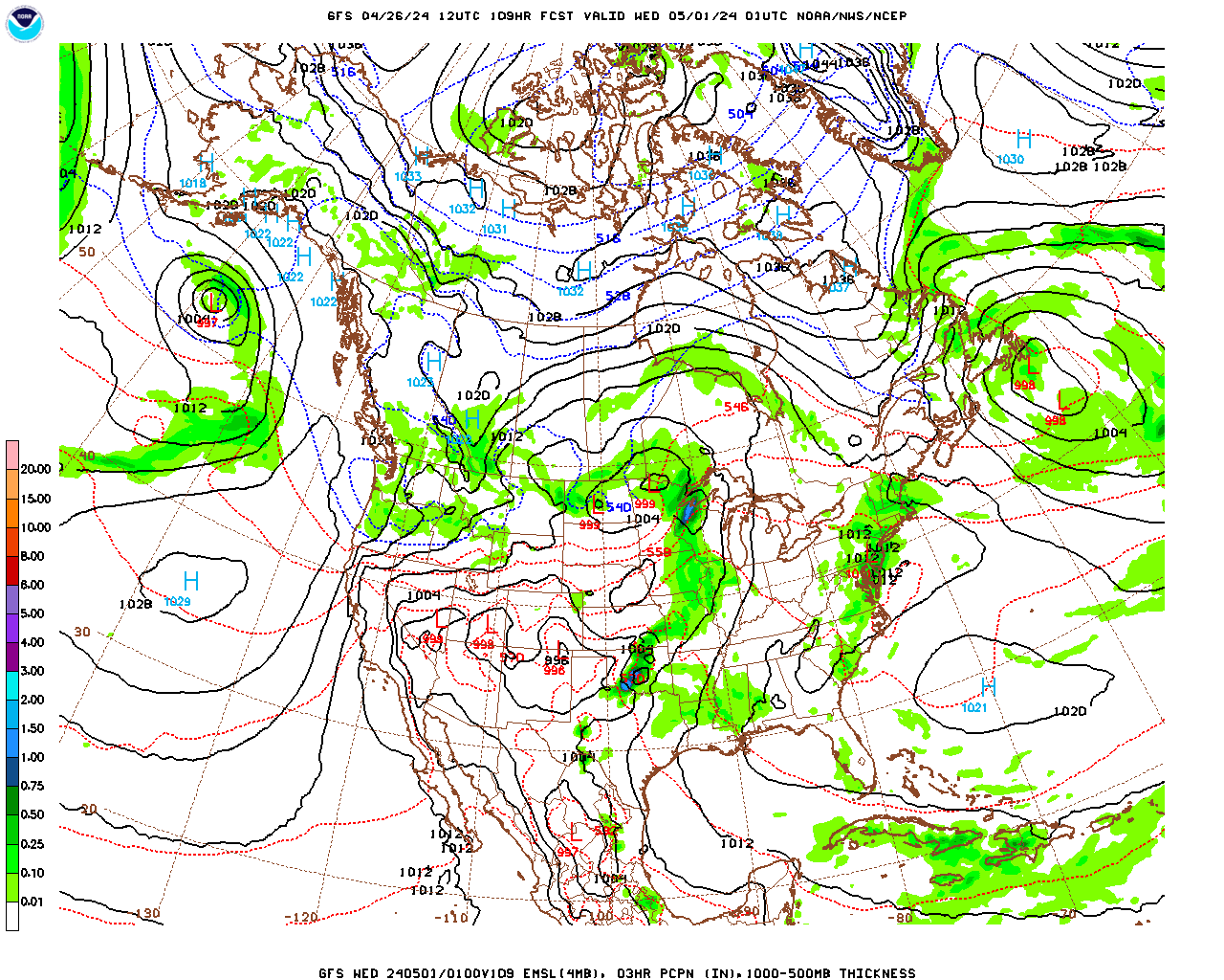
The upper-level trough will continue to broaden, with the polar front along its southern edge displaced well to our south, and be reinforced by cold disturbances moving out of Canada, so that the cold air associated with this feature will cover the entire northern tier of the US for several days, right through the weekend and into early next week. Therefore, temperatures will be below normal in Berkshire County right into early next week, with the coldest temperatures over the weekend. In fact we likely will not see above freezing temperatures until mid-week next week. Unfortunately for snow lovers, and all of the businesses in the county which depend upon it, there is unlikely to be much natural snow, as all of the surface lows which develop along the eastern edge of the trough, one on Friday, and a few over the weekend, should track out to sea to our south and east. At least it will be cold enough for the ski areas to make snow…..
Berkshire County Forecast
Tuesday Night
Steady rain early this evening, will likely lighten up and become more intermittent mid to late evening and end by 2 am or so. There may still be a few pockets of freezing rain over the highest terrain of North County. Remaining overcast once the rain ends. Probability of precipitation near 100%. Rainfall totals around 0.50″ this afternoon and evening. Temperatures holding steady in the mid 30s, low 30s over the highest terrain. Northeasterly winds at 5 – 10 mph this evening, becoming light westerly after midnight.
Wednesday
Mostly cloudy and cool. A few, widely scattered, light flurries or sprinkles are possible. Late afternoon it will become breezy and colder with a snow shower or squall more likely toward evening. Little or no accumulation for most locations with a quick dusting possible in any squalls that develop. Probability of precipitation 40%. Temperatures will rise only slightly with highs in the late morning to early afternoon in the mid to upper 30s in most locations, near 40 in the lower elevations of South County, and low to mid 30s over the elevated terrain. Light west-southwesterly winds in the morning becoming westerly at 10 – 15 mph in the afternoon, with a few higher gusts in any snow squalls which develop.
Wednesday Night
Variably cloudy, breezy and much colder. Low temperatures in the mid to upper teens, low teens over the elevated terrain. West-southwesterly winds at 10 – 20 mph with gusts to 25 mph. Wind chills dropping into the single digits.
Thursday
Some early morning sunshine, otherwise mostly cloudy, breezy and cold. High temperatures in the mid 20s in the lower elevations of central and northern Berkshire, upper 20s in the lower elevations of South County and low 20s over the elevated terrain. West-southwesterly winds at 10 – 20 mph, diminishing later in the afternoon.